Geographic Information System (GIS) Services
Library GIS support includes providing access to Esri ArcGIS software, in-course instruction and support, and individual consultations with faculty and students. We support beginning and advanced GIS topics including GPS-enabled field collection of data, the use of drones, and discovery of existing data sources for geospatial analysis.
A Geographic Information System (GIS) is a system designed to capture, store, manipulate, analyze, manage, and present all types of spatial related data. Most data is spatial therefore can be in some way referenced to locations on the earth and related to other information. GIS falls within the Geospatial umbrella that also encompasses Remote Sensing and field data collection methods such as GPS, the use of drones and satellite imagery. Most industries and areas of research benefit with the use of GIS.
Find a self-guided GIS course or tutorial, get instructions for downloading ArcGIS software, find links to useful data portals, and more.
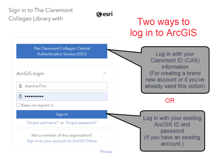
You can access ArcGIS Online directly with your Single Sign-On (SSO) credentials when you click “Sign In” from the Claremont Colleges Library ArcGIS Portal.
If you have existing credentials from ArcGIS Online, you can continue to log in with those.
If your ArcGIS Online credentials are managed through the Claremont Colleges central authentication services (CAS/SSO), you will no longer be able to access ArcGIS Online when those credentials expire.
We do not regularly delete content, but to ensure you have access to your content when you leave Claremont, you may want to investigate one of the following options.
Any questions? Please contact the Library GIS administrators at gis@claremont.edu.
The Digital Scholarship Unit at the Claremont Colleges Library offers consultation and support for faculty and students working with Unmanned Aerial Vehicles (UAV) or drone applications in GIS for research, teaching, and learning.
The library owns a DJI Phantom 4 Advanced and a Mavic 3E UAVs which we can use in support of research and teaching at the colleges (we do not loan the drones, but will set up a meeting with our drone pilot and the drone for your project).
Please get in touch with us if you need:
- The supervision/support of an FAA-licensed drone operator
- Use of photogrammetry applications (e.g., Pix4D) for processing drone imagery
- Consultations for support of student coursework involving drones
- Information about the Claremont Colleges drone policy and flight registration requirements
The library circulates four Bad Elf GPS PRO+ GPS units for use in course fieldwork, research projects, and for experimentation.
Join us for our Map Monday meetups to talk about GIS and get help with your projects!
Request a consultation, a course-integrated introduction to ArcGIS, instructional support for your geospatial projects on campus and while conducting field work.