Geographic Information System (GIS) Services
Library GIS support includes providing access to Esri ArcGIS software, in-course instruction and support, and individual consultations with faculty and students. We support beginning and advanced GIS topics including GPS-enabled field collection of data, the use of drones, and discovery of existing data sources for geospatial analysis.
A Geographic Information System (GIS) is a system designed to capture, store, manipulate, analyze, manage, and present all types of spatial related data. Most data is spatial therefore can be in some way referenced to locations on the earth and related to other information. GIS falls within the Geospatial umbrella that also encompasses Remote Sensing and field data collection methods such as GPS, the use of drones and satellite imagery. Most industries and areas of research benefit with the use of GIS.
Find a self-guided GIS course or tutorial, get instructions for downloading ArcGIS software, find links to useful data portals, and more.
You can access ArcGIS Online directly with your Single Sign-On (SSO) credentials when you click “Sign In” from the Claremont Colleges Library ArcGIS Portal. The Claremont Colleges Library Portal, sign in link is in the top right.

You will create a new account through The Claremont Colleges identity management/single sign-on (SSO) application. You will continue to use this method to log in every time. If you have older credentials (issued before 2020) you can continue to use the white ArcGIS Login box at the bottom

Explore quantitative information gathered about ArcGIS Online usage across the 7Cs.
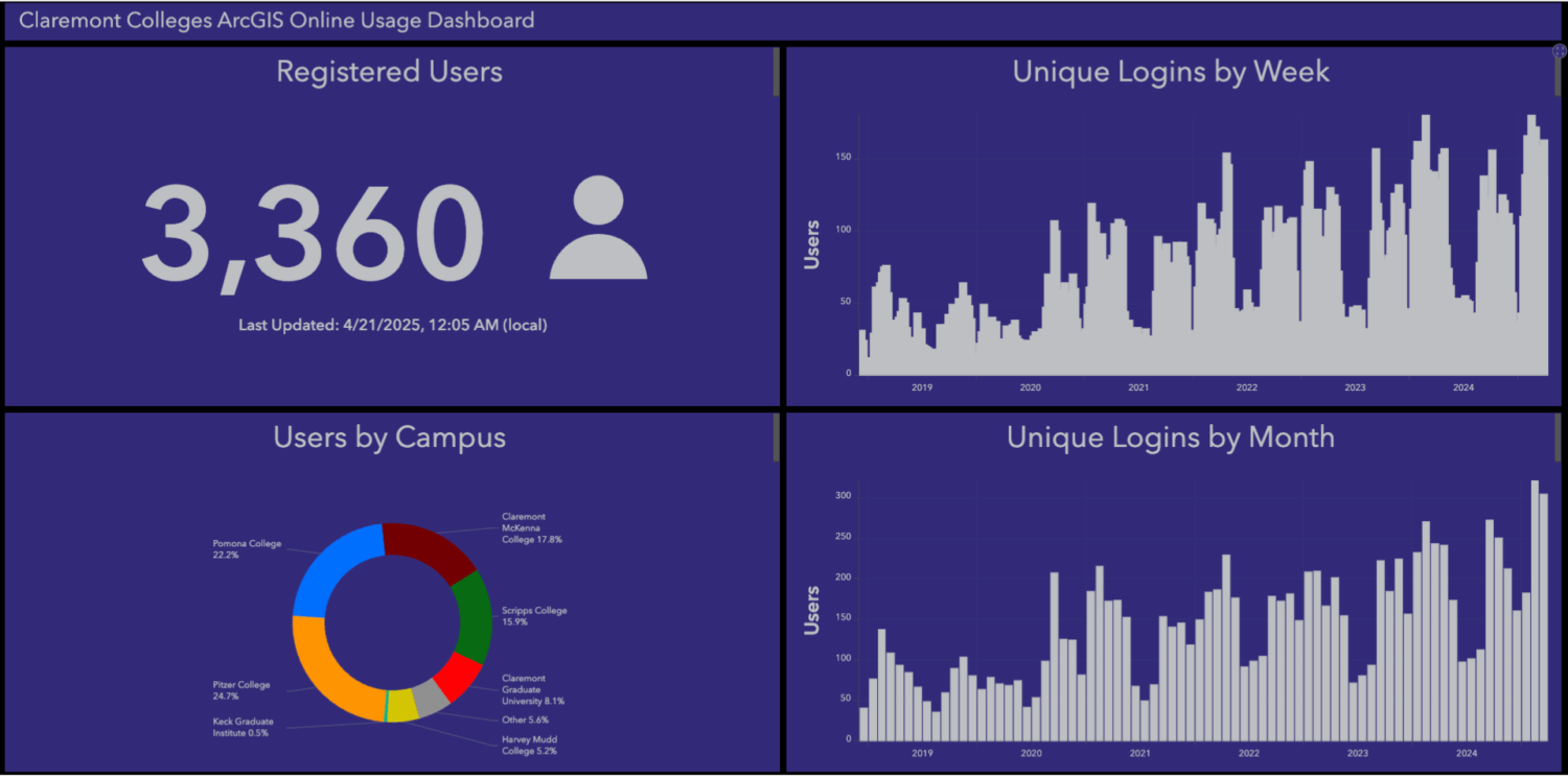
Access the DashboardThe Claremont Colleges ArcGIS Online Usage Dashboard provides an interactive overview of GIS engagement across the consortium. It offers insights into the community’s geospatial activities by displaying metrics such as the number of registered users, unique logins, and campus-specific usage statistics. The dashboard visualizes trends over time, highlighting the growth in ArcGIS Online adoption since 2020.
The Digital Scholarship Unit at the Claremont Colleges Library offers consultation and support for faculty and students working with Unmanned Aerial Vehicles (UAV) or drone applications in GIS for research, teaching, and learning.
The library owns a DJI Phantom 4 Advanced and a Mavic 3E UAVs which we can use in support of research and teaching at the colleges (we do not loan the drones, but will set up a meeting with our drone pilot and the drone for your project).
Please get in touch with us if you need:
- The supervision/support of an FAA-licensed drone operator
- Use of photogrammetry applications (e.g., Pix4D) for processing drone imagery
- Consultations for support of student coursework involving drones
- Information about the Claremont Colleges drone policy and flight registration requirements
Join us for our Map Monday meetups to talk about GIS and get help with your projects!
Explore our frequently asked questions to get the answers you need.
Request a consultation, a course-integrated introduction to ArcGIS, instructional support for your geospatial projects on campus and while conducting field work.